Trail Walking Val d'Anast - Circuit des étangs et des Landes - Campel - Photo

Circuit des étangs et des Landes - Campel

 tracegps
tracegps

User

© OpenStreetMap contributors
Length
Length
13.7 km
Max alt
Max alt
130 m
Uphill gradient
Uphill gradient
194 m
Km-Effort
Km-Effort  
16.3 km
Min alt
Min alt
78 m
Downhill gradient
Downhill gradient
194 m
Boucle
Boucle
Yes
Creation date :
2014-12-10 00:00:00.0
Updated on :
2014-12-10 00:00:00.0

(3 Reviews)

Walking
Walking
3h25
Difficulty : Difficult

Scan this QR Code to open this trail in the SityTrail application

FREE GPS app for hiking

Logo SityTrail SityTrail

IGN / Geographical institutes

Download SityTrail from the App Store Download SityTrail from Google Play

Logo SityTrail SityTrail World

The world is yours!

Download SityTrail from the App Store Download SityTrail from Google Play Download SityTrail on Huawei AppGallery

About

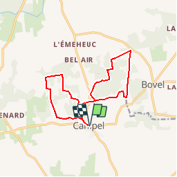
Trail Walking of 13.7 km to be discovered at Brittany, Ille-et-Vilaine, Val d'Anast. This trail is proposed by tracegps.

Description

Circuit proposé par la maison du tourisme du Pays de Redon . Départ de la place de l’église de Campel. Retrouvez le circuit sur le site du Pays de Redon.

Elevation profile

Photos

Positioning

Country:
France
Region :
Brittany
Department/Province :
Ille-et-Vilaine
Municipality :
Val d'Anast
Location:
Unknown
Start:(UTM)
574035 ; 5309708 (30T) N.

Comments

Please log in to post a review or rate the element


Sans intérêt réserver pour une balade le dimanche d'automne.


Balisage très moyen sur une partie du sentier.


Trails nearby

Trail Walking Val d'Anast - Les étangs de Campel - Photo
Walking
jackpot

Walking

Medium
Val d'Anast, Brittany, Ille-et-Vilaine, France
10 km | 11.7 km-effort
2h 41min
Yes
Trail Walking Val d'Anast - circuit des landes et des étangs. Campel - Photo
Walking
slm3005

Walking

Very easy
(1)
Val d'Anast, Brittany, Ille-et-Vilaine, France
14.9 km | 17.8 km-effort
3h 34min
Yes
Trail On foot Maxent - Circuit de L'Emeheuc - Photo
On foot
PRO

On foot

Easy
Maxent, Brittany, Ille-et-Vilaine, France
7.2 km | 8.5 km-effort
1h 55min
Yes
Trail Walking Bovel - Circuit du Bois de Cent Jours - Bovel - Photo
Walking
tracegps

Walking

Easy
Bovel, Brittany, Ille-et-Vilaine, France
5.6 km | 7 km-effort
1h 19min
Yes
Trail Walking Val d'Anast - campel - Photo
Walking
Erick Marteau

Walking

Medium
Val d'Anast, Brittany, Ille-et-Vilaine, France
14.1 km | 16.7 km-effort
3h 7min
Yes
Trail Walking Val d'Anast - campeljuin - Photo
Walking
ballay

Walking

Very easy
Val d'Anast, Brittany, Ille-et-Vilaine, France
12.2 km | 14.4 km-effort
2h 46min
No
Trail sport Val d'Anast - 2023-03-02_11h00m56_SityTrail - 3565569 - Campel_TA_Rando A+ - Photo
sport
ballay

sport

Very easy
Val d'Anast, Brittany, Ille-et-Vilaine, France
13.2 km | 15.8 km-effort
Unknown
No
Trail Walking Val d'Anast - 180 Rando des étangs et des Landes Campel - Photo
Walking
Pierre-yves Leclerc

Walking

Easy
Val d'Anast, Brittany, Ille-et-Vilaine, France
14.1 km | 16.7 km-effort
3h 11min
Yes
Trail Walking Val d'Anast - Campel 13/06/19 - Photo
Walking
nolsim

Walking

Very easy
Val d'Anast, Brittany, Ille-et-Vilaine, France
12.4 km | 14.7 km-effort
2h 42min
Yes


Close
My subscriptions